


Mapping a Risk-managed Route
UNL scientist says risks are manageable in new route proposed for Keystone XL Pipeline.
Potential groundwater contamination risks posed by the Keystone XL (KXL) pipeline in Nebraska are minimal and manageable under a “risk-managed” route proposed by a University of Nebraska–Lincoln (UNL) water scientist.
Roy Spalding, hydrochemist and water-quality expert, and Aaron Hirsh, graduate student, outlined the findings in a journal article about risk-managed approaches to routing petroleum pipelines. The article is in the Dec. 4 issue of Environmental Science and Technology, a long-standing and highly regarded journal published by the American Chemical Society, based in Washington, D.C.
The risk-managed route the authors propose for the Keystone XL pipeline in Nebraska “avoids the sensitive, highly vulnerable, agriculturally undeveloped land that elicited strong condemnation of the since-rejected original Keystone XL route,” Spalding said.
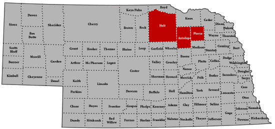
Their proposed southeasterly route through Holt, Antelope and Pierce counties, to the existing north-south Keystone 1 pipeline, avoids the Ogallala aquifer beneath the fragile and pristine Sandhills, subirrigated meadows and areas with very shallow water tables. The risk-managed route through these three counties is through overlying row-cropped land underlain by already contaminated Ogallala groundwater to the Keystone 1 corridor.
The north-south segment paralleling the Keystone corridor to Steele City avoids the Ogallala aquifer.
The proposed risk-managed pipeline route, in the Holt, Antelope and Pierce county areas, is essentially the same length as the recently proposed KXL route under consideration, but runs slightly south of it and avoids shallow groundwater. Once east of Pierce County, the risk-managed route drops almost due south, paralleling the Keystone 1 mainline pipeline.
Spalding, of UNL’s agronomy and horticulture department, and Hirsh, from the civil engineering department, point out that in Nebraska, where 85% of the population uses groundwater for its drinking water source, “threats to water quality are taken quite seriously” and that the routing of petroleum pipelines could be “made much more acceptable by adopting risk-managed routes that lessen the potential to adversely impact high-quality groundwater and, should a release occur, decrease the longevity and potential detrimental effects of hazardous groundwater contaminants.”
The article goes on to note that while pipeline spills have been dramatically reduced during the last 10 years, averaging fewer than one per 1,000 miles of pipeline over that period, “releases of hazardous petroleum chemicals to groundwater do occur and some should be expected.”
The potential risk of releases from the Keystone XL pipeline, or from any pipeline used to transport tar-sands oil, may increase from liquefying the asphalt-like tar sands with refinery condensate, or naptha, to form a more readily flowing mix of oil and diluents known in the oil industry as “dilbit.”
Little is known about the potential movement of dilbit to groundwater at release sites, the authors wrote. There are so many variables, including the chemical composition of the dilbit, ambient temperature, depth to groundwater, emergency cleanup practices and other factors, that predicting the exact mechanism of contaminant movement to the aquifer is complicated, Spalding and Hirsh’s article reports.
One of the best ways to minimize risks from a potential spill is to carefully select a pipeline route with minimal environmental risk and reasonable length, which the researchers say they have done with their newly proposed pipeline route.
The southeasterly course through intensely spray-irrigated, row-cropped land underlain by contaminated groundwater in Holt, Antelope and Pierce counties is “an opportunistic use of impaired groundwater and existing irrigation practices to remediate volatile petroleum contaminants and groundwater should a spill occur.”
Their proposed route also avoids high-quality Ogallala aquifer groundwater, as well as bottomland, high-water-table land and major river crossings, the authors say.
“Most importantly, the risk-managed approach is founded on the paradigm that siting the pipeline through an intensively spray-irrigated area overlain by a contaminated aquifer provides [for] both in-place and off-site remediation [of a spill]. Thus, routing through areas of intense spray irrigation (center pivots) is by design.”
Earlier research by Spalding has proven that many volatile hazardous compounds found in petroleum products, such as the benzene present in dilbit, can be stripped from the contaminated water by spraying it through a center pivot, where the compounds can then dissipate harmlessly as a gas into the atmosphere, making groundwater irrigation by center pivot along the proposed pipeline route a potential plus.
“Groundwater capture zones” created by wells pumping water to center pivots would also help contain and remove dissolved contaminants, Spalding said.
The majority of underlying groundwater in or near the proposed Keystone XL pipeline route is heavily laced with nitrate and sulfate contamination from fertilizer and soil amendments that have leached into the groundwater.
This nitrate contamination stretches for more than 100 miles and more than 1 million acres are underlain by non-potable high-nitrate Ogallala groundwater. Leached soil amendments enhance the degradation of hazardous petroleum compounds in groundwater, which is another plus to the article’s proposed route if a release should occur, the authors say.
“Most agriculturally based states have extensive areas with groundwater nitrate contamination similar to that in the three-county focus area (of the proposed pipeline).
Where appropriate, these contaminated areas deserve consideration in siting future routes for conveying liquid fuels,” Spalding and Hirsh said.
The Keystone XL pipeline is awaiting U.S. State Department action on an international permit to build the pipeline.
Editor’s Note: This release is from the University of Nebraska Institute of Agriculture and Natural Resources.

[Click here to go to the top of the page.]